
Has Development Occurred at the Expense of Indiana’s Prime Farmland?
Economic Research Analyst, Indiana Business Research Center, Kelley School of Business, Indiana University
From 1950 to 2007, the proportion of Indiana acreage devoted to farmland has decreased 24 percent (from 84.8 percent to 64.4 percent); meanwhile the population grew by 2.4 million, or 61 percent (see Figure 1).1 As a large percentage of the loss of farmland tends to occur at the periphery of urban areas, intense debates have occurred about the effects of urban sprawl on Indiana’s natural resources. For clarification, urban sprawl is the inefficient land use pattern associated with urban growth and development,2 and is often characterized by low density development occurring outside of urban areas. Developers argue that they build what people want according to market demands. Indeed, development is spurred by positive economic growth, which is desired in Indiana, but is this development occurring at the expense of Indiana’s prime farmland? Additionally, what farmland preservation policies does the state have in place to protect our best farmland? This article will look at the state’s agricultural trends, the distribution of prime farmland in Indiana, and projected urban growth patterns to address these important issues.
Figure 1: Percentage of Indiana’s Acreage in Farms and Population, 1950 to 2007
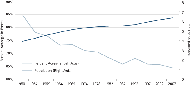
Notes: Differences in time intervals are due to the Census of Agriculture being taken every ten years prior to 1950. After that, the Census was taken every four or five years until 1982 where it now occurs every five years.
Source: IBRC, using USDA Census of Agriculture and U.S. Census Bureau data
Importance of Agriculture to Indiana
The Indiana agriculture industry is a large contributor to our state’s economy at an estimated $25 billion a year.3 Not only is Indiana ranked in the top ten in sales volume for corn, soybeans, poultry, hogs, as well as milk and other dairy products, the agriculture industry comprised roughly 17.6 percent of the state’s exports with a value of $5.3 billion in 2008. For an industry that only employs 4.5 percent of Hoosiers, the output is quite impressive.4
To give perspective on which counties are the leading producers of various commodities, Figure 2 shows the top ten counties for producing field corn, soybeans, wheat, hay, popcorn, vegetables, fruits, cut Christmas trees, cattle (beef and dairy), hogs, sheep, poultry (chickens and turkeys), and goats. As expected, some counties are “super-producers” and are ranked in the top ten for numerous commodities. These include Elkhart County (a top ten producer for seven commodities), Washington County (seven commodities), LaGrange County (six commodities), and Adams County (five commodities).
Figure 2: Top Ten Producing Counties of Agriculture Commodities
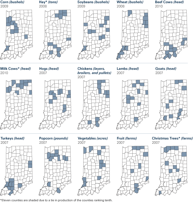
Sources: IBRC; Most data came from the Indiana Agricultural Statistics 2008-2009 and reflect 2008 data, except corn, soybeans and wheat which reflect 2009 data from the National Agricultural Statistics Service (NASS). Beef and milk cows as of inventory in January 2009 data also came from the Indiana Agricultural Statistics Office (NASS). Data for vegetables, fruits, and Christmas trees came from the 2007 Census of Agriculture and are provided in acres and number of farms due to the amount of non-disclosable data. All other animal data came from the 2007 Census of Agriculture Report.
Prime Farmland in Indiana
The U.S. Department of Agriculture (USDA) defines prime farmland (Capability Class I and II) as land best suited to food, feed, forage, fiber, and oilseed crops. This land has the soil qualities, growing season, and moisture supply needed to economically produce a sustained high yield of crops. Therefore, prime farmland produces the highest yields with minimal inputs of energy and economic resources, resulting in the least damage to the environment. The loss of prime farmland to other uses (i.e., urban development) forces the producer to use marginal lands, which typically are more erodible, more prone to drought, less productive, and not as easily cultivated for field use.5 In order to make marginal lands more productive, operators would need to apply more inputs such as water, chemicals and fertilizers, tile (for drainage), and other technologies, which affects the operator’s bottom line and could impact the environment.6
In 1997, the United States had a total of 331.9 million acres in prime farmland, a decline of 13.6 percent from 1977.7 In Indiana, 56.4 percent of our farmland, or 12.9 million acres, was defined as prime farmland, making Indiana one of the three states to have over 50 percent of its farmland area classified as prime farmland, behind Iowa (66.3 percent) and Illinois (58.7 percent).8 Figure 3 shows that the counties with total land area classified as over 80 percent prime farmland are mostly clustered in north-central Indiana up to the northeastern corridor of the state.
Figure 3: Percentage of County Land Area Classified as Prime Farmland
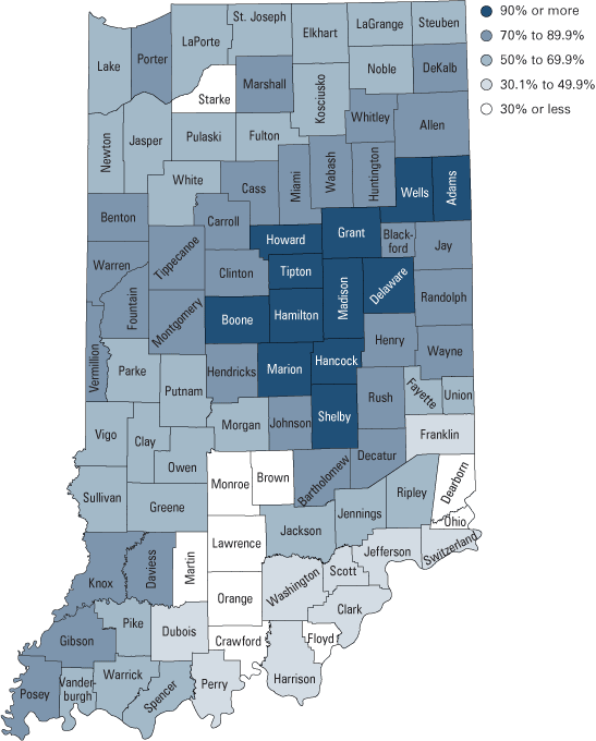
Note: These percentages are based on total land area.
Source: IBRC, using STATSGO data (1994 National Cooperative Soil Survey, USDA)
Unfortunately, as noted by researcher Arthur Nelson, most of the United States’ prime farmland is located within the suburban and exurban counties of metropolitan areas.9 Therefore, the land that is most suitable for agricultural production tends to be equally desirable for development.10 This was seen between 1992 and 1997 when Indiana saw 144,000 acres—86.3 percent of that classified as prime farmland—converted to developed uses.11 Regrettably, these lands that are developed are likely to never be reconverted to agricultural uses.12
Past, Current, and Projected Growth in Central Indiana
For the remainder of the article, focus will be directed to the central Indiana region of forty-four counties (see Figure 4) that are dispersed within six Economic Growth Regions (EGRs) as defined by the Department of Workforce Development (DWD). Of these counties, 23 (52.3 percent) have 80 percent or more of their land area classified as prime farmland. Twelve counties have between 60 and 79.9 percent of their land area as prime farmland, with the remaining nine counties at less than 60 percent.
Figure 4: Central Indiana Region*
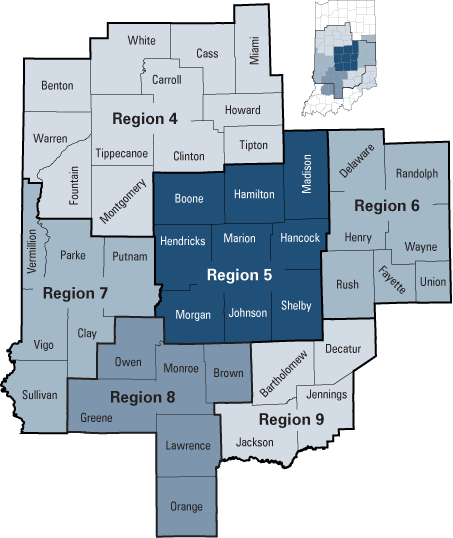
*This region consists of forty-four counties dispersed among six Economic Growth Regions (EGRs). Note that EGRs 6, 8, and 9 contain counties that are not included in this forty-four county region. All analysis is limited to the counties shown.
Source: IBRC
Between 1950 and 2009, it is estimated that Indiana’s total population grew 63 percent and the forty-four county region’s growth rate was 72 percent. However, the counties surrounding Indianapolis (Boone, Hendricks, Morgan, Marion, Johnson, Shelby, Hancock, and Madison) led the regions with a growth rate of 108 percent. The county with the most explosive growth was Hamilton (880 percent) followed by Hendricks and Johnson counties (472 percent and 440 percent, respectively), as shown in Figure 5.
Figure 5: Population Growth Trends, 1950 to 2009
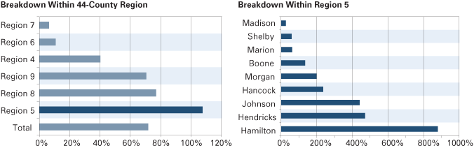
Source: IBRC, using U.S. Census Bureau data
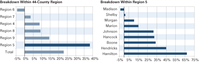
Due to the surge in population, the population density has also increased dramatically (see Table 1). Within the forty-four county region, those counties in regions 5, 8, and 9 have grown between 16 to 38 percent from 1980 to 2009, yet doubled or nearly doubled their population density since 1950. Again, Hamilton County lead the way, increasing its population density from 206.1 people per square mile in 1980 to 701.8 people per square mile in 2009. In conjunction with the population growth, counties also saw an increase in housing units and other developed parcels of land devoted to businesses and public infrastructure. The state’s official population estimates for the years 2005 to 2040 produced by the Indiana Business Research Center show that Region 5 will continue to grow at a fast clip of 31.3 percent (see Figure 6). Hamilton and Hendricks counties will continue to dominate the population growth with 84 percent and 54 percent growth between 2005 and 2040.
Table 1: Population Density, 1980 and 2009
| Area | 1980 | 2009 |
|---|---|---|
| Breakdown of 44-County Region | ||
| Average | 155.8 | 189.5 |
| Region 5 | 383.5 | 528.0 |
| Region 6 | 134.2 | 119.5 |
| Region 8 | 88.1 | 107.9 |
| Region 9 | 89.1 | 102.9 |
| Region 4 | 96.3 | 101.4 |
| Region 7 | 94.0 | 93.6 |
| Breakdown of Region 5 | ||
| Marion | 1,931.2 | 2,248.3 |
| Hamilton | 206.1 | 701.8 |
| Johnson | 241.2 | 441.9 |
| Hendricks | 170.9 | 344.3 |
| Madison | 308.2 | 290.7 |
| Hancock | 143.5 | 223.2 |
| Morgan | 127.9 | 174.4 |
| Boone | 83.8 | 133.1 |
| Shelby | 96.7 | 107.8 |
Figure 6: Projected Population Growth, 2005 to 2040
Source: IBRC
The maps in Figure 7 display today’s land use and projected land use change through 2040. The Center for Urban Policy and the Environment at Indiana University–Purdue University Indianapolis created the luci2 Urban Simulation Model that projects development scenarios in the central Indiana region, using 2000 data as the base model.13 The maps for 2010 and 2040 utilize the IBRC population projection data to project the urban growth areas. Comparing these maps, one can see that the Indianapolis metropolitan area is projected to spread further into the counties surrounding Marion County. Outlying areas with prior urban development will also continue to grow and expand. This expansion of urban areas equates to nearly 500,000 acres being converted to urban lands between 2000 and 2040. Of this figure, slightly more than 270,000 agricultural land acres would be converted (54.1 percent), which means an average loss of 6,752 acres per year. This would equate to a loss of at least 28 farms a year (using the 2007 average farm size of 242 acres), for a total loss of 1,116 farms or more. Unfortunately, roughly 68 percent of this farmland loss will be in areas with high amounts of prime farmland (greater than 80 percent), which makes the loss of farmland even more significant.
Figure 7: Land Classified as Urban in Central Indiana under Current Trends, 2010 and 2040
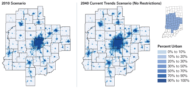
Source: IBRC, using Center for Urban Policy and the Environment data
Smart Growth and Indiana Farmland Preservation Policies
Since the mid-1990s, “smart growth” has become a popular term for how to combat urban sprawl and compact development while preserving rural lands. Unfortunately, smart growth is difficult to define due to its various potential elements, which can include adoption of fiscal resource sharing amongst localities; promotion of compact, mixed-used development; and preservation of open space. The opposite of smart growth can be more broadly defined as sprawling, haphazard, and poorly planned development in the outer suburbs and exurbs that also dilute the economic and social vitality of cities and older suburbs.14
The movement to preserve privately held land began in the 1980s after the federal government’s relaxed environmental laws and reduced federal land acquisition programs, spurring the increase in private nonprofit land trusts. The rise in land trusts also grew due to frustrations with communities’ rapid pace of growth and the ineffectiveness of local planning to protect important landscapes and natural resources.15 Indiana currently has a Nature Conservatory and twenty-five different land trusts that purchase land and conservation easements to buffer habitats they don’t want developed, including some farmland. While helpful, these programs still do not entirely address the issue regarding the loss of prime farmland near metropolitan areas.
Presently, Indiana does not have statewide farmland preservation policies in place to address the rapid growth of urban and low density development onto prime farmland. However, Indiana does have the Indiana Land Resources Council (ILRC) that provides assistance to counties regarding planning and zoning ordinances. A recent initiative that the ILRC has been working on is agricultural zoning that assists communities with implementing regulations that help strike a balance between competing land uses. This is a critical initiative as seventy-nine of the state’s ninety-two counties have different planning and zoning ordinances, several of which may be dated. The remaining thirteen counties have no traditional regulations in place. The ILRC looks at agricultural zoning from an economic and fiscal standpoint that shows that it is optimal to keep farmland (especially prime farmland) in agricultural production and why it’s important to keep agriculture in the community development plan. While this approach may be considered non-traditional compared to other states’ farmland preservation policies, planning and zoning are critical cornerstones that need to be in place before the state (or county) pursues conservation policies.16
Critics of land preservation policies argue that the land market should dictate the rate of development; however, the land market has repeatedly failed to create satisfactory land use patterns. Instead, since land markets are influenced by public infrastructure investments in roads, schools, and sewer and water facilities, and by local governments whose primary interest is to expand the property tax base, the land markets have encouraged residential and commercial sprawl. A local government’s interest in expanding the property tax base over land preservation policies is often misguided as numerous cost-of-community-services studies done by the American Farmland Trust show that residential development demands more in public services than it generates in property taxes, whereas farmland generates more in property taxes than it demands in services.17 This fall, Indiana voters will have the opportunity to reinforce this paradigm if property taxes are capped at 1 percent, 2 percent, and 3 percent for residential, rental and farmland, and other business establishments, respectively.
The luci2 model allows for policy changes such as the development of new interstates and restrictions on sensitive lands. To visualize how development would change in central Indiana if restrictions were imposed on agricultural and sensitive land, another map was created that imposed development restrictions on agricultural land, wetlands, and forests (see Figure 8). The following conditions were applied that restricted development on: 1) wetlands greater than 20 acres; 2) forested areas greater than 20 acres; and 3) areas with at least 50 percent of land devoted to agriculture production (would keep 75 percent of that area in agricultural production). With this protection, slightly more than six million acres are restricted from development with the majority in agricultural land (75.4 percent). As expected, development on agricultural lands will still occur, just not as intensely as in the previous current trends scenario. The map shows that intense development is kept closer to the core of urban areas, and the percentage of acres in urbanized areas in Hamilton, Hendricks, Hancock, Boone, and Shelby counties decreases, albeit slightly.
Figure 8: Impact of Development Restrictions on Land Classified as Urban, 2040
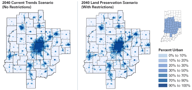
Source: IBRC, using Center for Urban Policy and the Environment data
Conclusion
Indiana is fortunate to have slightly more than 56 percent of all its farmland classified as prime farmland, a contributing factor to the state’s abundant agricultural production. In fact, many individuals have the mindset that there is not a shortage of farmland, thus no need to be concerned about the loss of farmland to development. This mindset could be reinforced by data showing that Indiana has continued to increase its agricultural production while losing farmland. Indeed, the agriculture industry has adapted to the loss of farmland through the growth of small (one to nine acres) and large (greater than 2,000 acres) farms between 1987 and 2007 (78.5 and 80.2 percent, respectively). However, some of the state’s most desirable land near metropolitan areas is in a tug of war between agricultural production and development. The state’s farmland is a limited natural resource and, once converted to development, is unlikely to be reconverted to agricultural use in the future. Therefore, it is necessary to carefully guide the development around metropolitan areas to preserve prime farmland, while recognizing that the agricultural industry is a large contributor to our state’s economy. How this challenge is addressed does not have a direct solution, but the ILRC is approaching this challenge through agricultural zoning, which will help communities better protect and understand the value that agricultural land brings to Indiana’s state and local economies by managing urban development in a smart way.
Endnotes
- Farmland data reflect the 1950 and 2007 Census of Agriculture reports and the population data is derived from the 1950 Census and population estimates for July 1, 2007. National Resources Inventory data would have been used if the data were more recent than 1997. It is believed that the NRI analysis is more accurate than Census data; for more information, see note 12.
- R. K. Olson and T. A. Lyson, Under the Blade: The Conversion of Agricultural Landscapes (Boulder, CO: Westview Press, 1999).
- See www.in.gov/isda/files/AEDI_Phase_II_Exec_Summ.pdf.
- For more details about agriculture’s contribution to the state’s economy, please see Tanya Hall, “The Importance of Indiana Agriculture,” InContext, May-June 2010, www.incontext.indiana.edu/2010/may-june/article3.asp.
- Definition obtained from the Indiana Soil Surveys (division of USDA’s Soil Conservation Service.
- A. Altshuler, The Urban Transportation System: Policies and Policy Innovation (Cambridge, MA: Joint Center for Urban Studies, 1979).
- Data came from the National Resources Conservation Service (NRCS), Natural Resource Inventory 1997 and D. R. Vining, K. Bieri, and A. Strauss, “Urban encroachment on prime agricultural land in the United States,” International Regional Science Review 2, no. 2.
- Data came from NRCS, Natural Resource Inventory 1997 and 1990 Census (for land area).
- A. Nelson, “Economic Critique of U.S. Prime Farmland Preservation Policies,” Journal of Rural Studies 6, no. 2 (1990): 119-142.
- B. Solomon, “Farmland Protection: A Case of Quality Not Quantity,” Land Use Policy (October 1984): 357–66.
- Farmland Information Center on Indiana Statistics derived from the National Resources Inventory (NRCS).
- A. Thompson and L. Prokopy, “Tracking Urban Sprawl: Using Spatial Data to Inform Farmland Preservation Policy,” Land Use Policy 26 (2009): 194–202.
- The luci2 model can be found at https://slideplayer.com/slide/4982447/.
- T. Daniels and M. Lapping, “Land Preservation: An Essential Ingredient in Smart Growth,” Journal of Planning Literature 19 (2005): 316–329.
- See note 14.
- Information obtained from Executive Director Sarah Simpson via interview. More information about ILRC and agricultural zoning can be found at www.in.gov/isda/files/ILRC_Model_Ordinances_-_Updated_2014.pdf.
- See note 14.