
Dimensions of Indiana Poverty
Postdoctoral Scholar, Northeast Regional Center for Rural Development, Penn State University
Director and Professor, Center for Regional Development, Purdue University
GIS & Data Analyst, Center for Regional Development, Purdue University
Regional Planner: GIS and Spatial Analysis, Center for Regional Development, Purdue University

Despite recent economic growth, 39.7 million Americans (or 12.3 percent) lived in poverty in 2017, 12.8 million of whom were children under 18 years of age (Fontenot, Semega, & Kollar, 2018). However, this deprivation of resources is not spread evenly throughout the country’s population. Personal characteristics—such as education level, family structure, race and ethnicity—may be related to how likely individuals are to be poor. Moreover, the built environment, social structures and economic prosperity of their community may further affect the probability of being poor. Impoverished individuals are often clustered within specific communities, resulting in an uneven distribution throughout the country.
This combination of factors—some stemming from individual choices and others from general economic trends and community composition—results in a complex problem that is difficult to fully address through a single approach. Researchers, policy analysts and community development practitioners usually choose to study poverty and its underlying mechanisms by focusing either on poor individuals or poor places. In this article, we explore poor places nationwide over time and at different geographic levels, giving special attention to conditions in the state of Indiana.
The poverty rate is the percentage of the population with money income below the poverty line. Because poor individuals are not evenly spread throughout the country, poverty rates change based on which spatial scale is used (Peters, 2012).
- Macro scale: These national and regional data present averages and general trends in the population.
- Meso scale: These data allow for some locational differences by describing “intermediate” places, such as states, metropolitan areas and counties.
- Micro scale: The smallest places, such as cities and census tracts, describe the communities in which people live.
Focusing on only one scale may obscure trends in poverty that would be apparent at a larger or smaller scale (Lichter, Parisi, Taquino, & Beaulieu, 2008). To account for differences due to spatial scale, we discuss regional, state, county and census tract trends for Indiana. This helps position Indiana within the bigger national and regional picture, while also addressing the variations that exist within the state.
Our analysis utilizes a spatially harmonized data set of poverty rates and a handful of other socio-economic variables from 1970 to 2016. We derive our measures of interest, persistent poverty and high individual and child poverty rates, based on the harmonized data. The data set keeps the borders of places, especially census tracts, constant over time, which allows us to track changes in poverty with some degree of accuracy. The harmonized data were created by the Purdue Center for Regional Development (PCRD) using data from five decennial censuses (1970 to 2010) and the 2012-2016 American Community Survey (Kumar & Kim, 2017).
High individual poverty patterns and trends
Places with 20 percent or more of their population living in poverty are designated as high-poverty places. Figure 1 shows the 2016 poverty rates in U.S. counties. Poverty rates are higher in the South, particularly in the Black Belt and along the Rio Grande, in counties with large Native American populations in the West and North Central regions, as well as in the Appalachians. Comparatively, Indiana had few high-poverty counties in 2016.
Figure 1: Individual poverty rates in U.S. counties, 2016
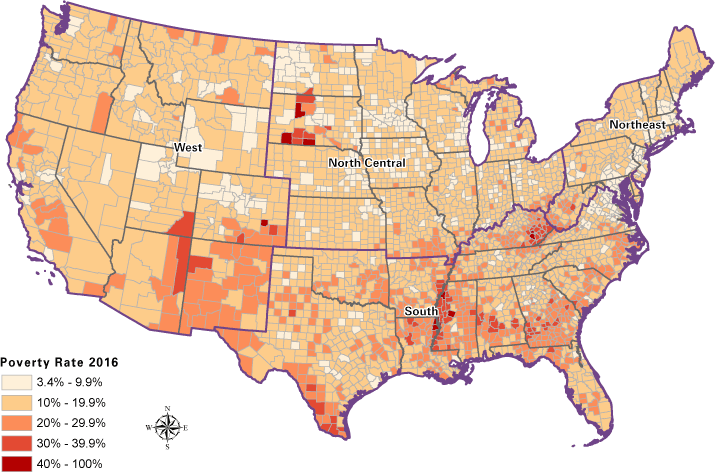
Note: In high-poverty counties, at least 20 percent of the population is living in poverty. Extremely high-poverty counties have a poverty rate of 40 percent or higher.
Source: U.S. Census Bureau (ACS 2012-2016 and SAIPE 2016), PCRD Dimensions of Poverty Project
Next, we compare Indiana to other states within the North Central region of the United States. Figure 2 shows the number of high-poverty counties and census tracts in the North Central region by state from 1970 to 2016. States are ordered, left to right, first by the total number of high-poverty places during the time period, then by alphabetical order. The ordering indicates that when counties, a meso scale unit, are used to analyze poverty rates, Missouri had the greatest number of high-poverty counties in the North Central United States, followed by South Dakota and North Dakota. There were no high-poverty counties in Indiana until 2010, and the state is tied with Kansas in third-to-last place with a total of eight high-poverty counties, five in 2010 and three in 2016.
Figure 2: Number of high-poverty counties and tracts by North Central state, 1970–2016
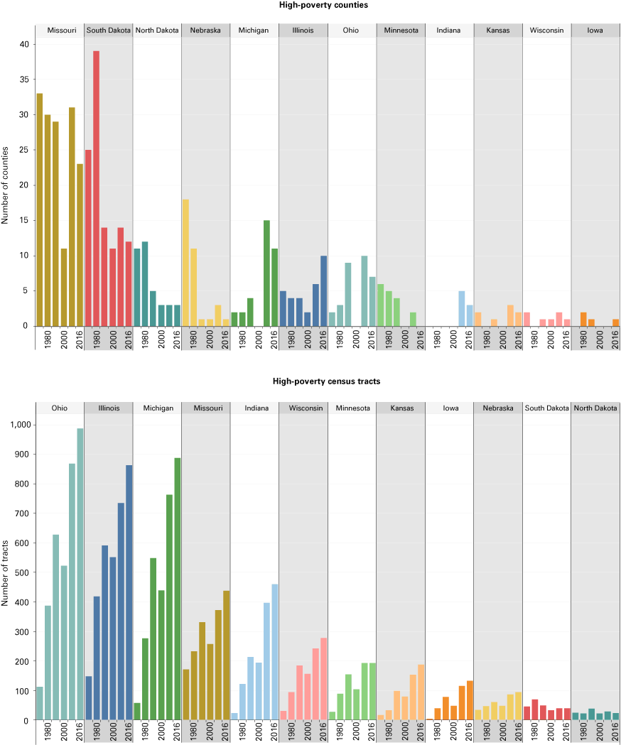
Note: The charts compare the number of high-poverty locations in a state over time. High-poverty locations have a poverty rate of at least 20 percent. The North Central Region includes Illinois, Indiana, Iowa, Kansas, Michigan, Minnesota, Missouri, Nebraska, North Dakota, Ohio, South Dakota and Wisconsin.
Source: U.S. Census Bureau (Decennial Census 1970, 1980, 1990, 2000, 2010, ACS 2006-2010, ACS 2012-2016, SAIPE 2000, SAIPE 2010 and SAIPE 2016), PCRD Dimensions of Poverty
However, when census tracts—a micro scale unit—are used for analysis, Ohio had the greatest number (and percentage) of high-poverty places, followed by Illinois and Michigan. Indiana had the fifth-highest number and fourth-highest percentage of high-poverty tracts in the North Central region between 1970 and 2016. The number of high-poverty tracts in the state swelled from 23 tracts in 1970 to 460 in 2016. North Dakota, which was ranked third (both as a number and as a percentage) when studying counties, is ranked last when studying census tracts. This clearly illustrates the importance of spatial scale when analyzing poverty using places.
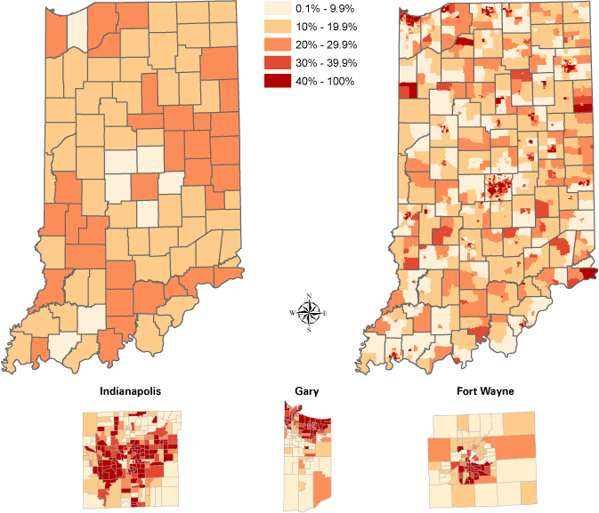
Our analysis, thus far, demonstrates that the number of high-poverty places varies across the North Central region. Indiana also shows this spatial variation. Figure 3 maps both county-level (left) and census tract-level (right) individual poverty rates in Indiana for 2016. Inset maps of Marion County (Indianapolis), Lake County (Gary) and Allen County (Fort Wayne) provide a higher-resolution picture of census tracts within these highly populated counties. Two of Indiana’s three high-poverty counties, Delaware and Monroe, are considered urban, while the third, Grant County, contains a mix of urban and rural land. Individual poverty rates can be affected by college students who are residing outside of dormitories; hence, counties with major universities may exhibit higher individual poverty rates. This may be the case in Indiana’s three high-poverty counties, as they each host universities (Ball State, Indiana University, Indiana Wesleyan and Taylor).
Figure 3: County and census tract individual poverty rates in Indiana, 2016
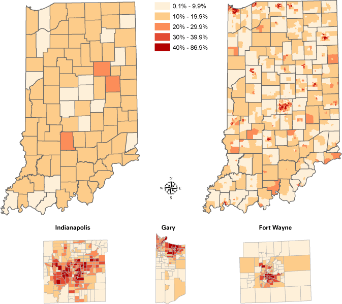
Note: The maps display county-level (left) and census tract-level (right) poverty rates in Indiana in 2016. In high-poverty locations at least 20 percent of the population is living in poverty. Extremely high-poverty locations have a poverty rate of 40 percent or higher. Inset maps are drawn at different scales.
Source: U.S. Census Bureau (ACS 2012-2016 and SAIPE 2016), PCRD Dimensions of Poverty Project
Indiana does not appear to have any specific county-level poverty pattern; however, the highest rates of tract-level poverty in the state occur within cities. The poverty rate in the 10 highest-poverty census tracts exceeds 66 percent of the population, while the poverty rate can be less than 1 percent in the lowest-poverty census tracts. The distribution of poverty across metropolitan and nonmetropolitan Indiana is similar to that of the rest of the North Central region—there is a larger proportion of high-poverty tracts in metropolitan areas, especially in the inner cities, but there are many high-poverty tracts in nonmetropolitan locations as well.
Persistent poverty
When a county has a high poverty rate over at least three time periods, it is considered persistently poor.1 The number of American counties with persistent high poverty has decreased since the 1970s, likely due to robust economic expansion during the 1990s. However, the proportion of persistently highly poor counties in the North Central region has remained approximately the same at about 8 percent. The majority of these persistently poor counties within the region are in Missouri and South Dakota; Indiana has none.
The picture changes when shifting from counties to census tracts. Indiana does have persistently poor census tracts, and the number has grown over time. In 1990, 21 Indiana census tracts had been highly poor since 1970, but by 2016, the number of persistently highly poor census tracts (with high poverty since 2000) had risen to 170 (11 percent). This increase is similar to that seen in the North Central region overall. In the region, only 3 percent of tracts had persistently high poverty rates in 1990, while more than 12 percent were classified as persistently poor in 2016. Figure 4 maps Indiana's persistently poor census tracts in 2016. The individual poverty rate in these tracts has been high for nearly 20 years. They are primarily located in or near cities, although not all cities in Indiana have persistently poor places.
Figure 4: Census tracts with persistently high individual poverty rates in Indiana, 2016
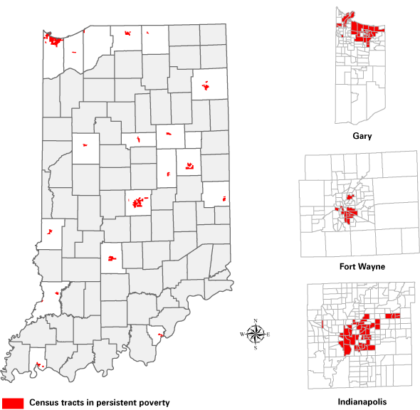
Note: A tract has persistently high poverty when at least 20 percent of the population is living in poverty for three time periods. Tracts in these maps had a high rate of individual poverty in 2000, 2010 and 2016. Inset maps are drawn at different scales.
Source: U.S. Census Bureau (Decennial Census 2000, 2010, ACS 2006-2010 and ACS 2012-2016), PCRD Dimensions of Poverty Project
High child poverty patterns and trends
Places where at least 20 percent of children (under 18 years of age) are poor are designated as having high child poverty. A child is considered poor if his or her family’s income is below the poverty line. Being poor as a child can have long-term impacts on an individual, affecting future outcomes such as family stability, educational attainment and workforce success (USDA ERS, 2019). It, therefore, serves as an early signal of national well-being. In 2016, more than 58 percent of American counties had high child poverty rates, nearly twice as many as in 1980. Counties with high child poverty in the North Central region increased from 192 to 349 over this time period.
Within the region, trends varied by state, with general declines in the number of counties with high child poverty in North Dakota and South Dakota, generally steady levels in Nebraska, Iowa and Minnesota, and general increases in all remaining states. Indiana stands out from other states within the region due to its drastic change in high child poverty counties after the Great Recession. Prior to the Great Recession, only between 1 percent and 7 percent of counties had high child poverty rates, but afterward, more than one-third to one-half of counties had high child poverty rates. While Missouri, Michigan and other states continue to have a larger proportion of high child poverty counties than is the case in Indiana, the difference between pre- and post-Great Recession percentages is particularly large in Indiana.
As with high poverty for individuals, Ohio leads the North Central region with the largest number (and percentage) of census tracts with high child poverty. Similar to its individual high poverty ranking, Indiana continues to be ranked the fifth-highest state in the region by the number of tracts with high child poverty between 1980 and 2016. However, it ranks third in the percentage of tracts with high child poverty.
When looking at high child poverty, a more distinct spatial pattern emerges at the county level than was the case for individual poverty. There are three groups of high child poverty counties:
- Along the shore of Lake Michigan
- Northeast of Indianapolis
- Along a line southwest of Indianapolis
These groupings are apparent in Figure 5, which maps county-level (left) and census tract-level (right) child poverty rates in Indiana in 2016, along with inset maps of Allen, Lake and Marion counties. In each of the top 10 counties on this measure, between 25 and 30 percent of children are living in poverty.
Figure 5: County and census tract child poverty rates in Indiana, 2016
Note: The maps display county-level (left) and census tract-level (right) child poverty rates in Indiana in 2016. In high-poverty locations, at least 20 percent of children are living in poverty. Extremely high-poverty locations have a child poverty rate of 40 percent or higher. Inset maps are drawn at different scales.
Source: U.S. Census Bureau (ACS 2012-2016 and SAIPE 2016), PCRD Dimensions of Poverty Project
The top 10 census tracts have much higher child poverty rates (greater than 80 percent), while some census tracts have a child poverty rate of less than 1 percent or no child poverty at all. The urban spatial patterns that are so apparent at the tract level where high individual poverty is concerned still occur with child poverty, but the pattern is blurred by the large number of rural census tracts throughout Indiana with high and extremely high levels of child poverty. This reflects a greater trend within the North Central region—a quarter of census tracts with high child poverty are in nonmetropolitan areas, and nearly 43 percent of the nonmetro population lives in a tract with high child poverty.
Discussion and conclusion
Clearly, the poverty patterns and trends we observe in Indiana and the North Central region are influenced by the geography, time period and population groups analyzed. Figure 6 compares the percentage of counties and census tracts (our two geographic dimensions) with high poverty across our two population dimensions (individuals and children) over various time periods.
Figure 6: Percent of high-poverty counties and census tracts in Indiana
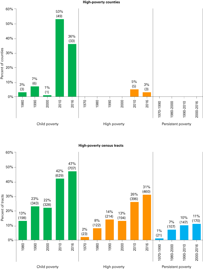
Note: The charts compare the rates of high child poverty (under 18 years old), high individual poverty (all ages) and persistently high individual poverty (over 20 years). High poverty places have a poverty rate of 20 percent or greater. The number of places is given in parenthesis below each percentage.
Source: U.S. Census Bureau (Decennial Census 1970, 1980, 1990, 2000, 2010, ACS 2006-2010, ACS 2012-2016, SAIPE 2000, SAIPE 2010 and SAIPE 2016), PCRD Dimensions of Poverty
Several facts emerge from our analysis of the dimensions of poverty in Indiana.
- At the meso scale, Indiana counties are doing well compared to counties in other North Central states and the nation.
- High poverty at the census tract level (poverty at the micro scale) is increasing over time in Indiana for both individuals and children.
- High child poverty is far more prevalent in the state than high individual poverty.
- Indiana experienced large increases in the proportion of both counties and census tracts with high individual and high child poverty after the Great Recession, and these values have not yet returned to pre-recession levels.
While place-based poverty analysis cannot make any connections between personal characteristics and poverty, it can track population patterns that are associated with high poverty levels. Places with high child poverty in the North Central region are more likely to have a higher percentage of black residents and fewer college graduates. Further, more single-mother households are found in counties with high child poverty, as well as in high individual poverty census tracts.
This article has only touched upon the ways in which spatial and temporal dimensions may affect our understanding of poverty. The unique spatial patterns of poverty indicate the importance of place-based approaches for poverty alleviation and economic development. Despite our emphasis on the importance of place when studying poverty, we neither champion research and policies focused on people nor on places. Instead, the persistence of poverty through the decades calls for an innovative, but pragmatic, approach to policies and practices that can reduce the prevalence and persistence of poverty in the state and beyond.
For more information on the study of poverty in places, refer to “The Study of Poverty in Places: Scope, Scale, and Space” (forthcoming). Additional information on the dimensions of poverty in the North Central region is available through the Purdue Center for Regional Development’s Dimensions of Poverty website (www.pcrd.purdue.edu/ncpoverty).
Notes
- There is some variation in how researchers define persistent poverty. Some researchers, such as Partridge and Rickman (2005) define persistent poverty as a 20-year stretch over three time periods, while others, such as those at the U.S. Department of Agriculture’s Economic Research Service, use a 30-year stretch over four time periods.
References
- Dobis, E. A., Beaulieu, L. J., & Kumar, I. (Forthcoming). “The study of poverty in places: Scope, scale, and space.” In R. Phillips and E. Trevan (Eds.), Research Handbook on Community Development. Cheltenham, UK: Edward Elgar Publishing.
- Fontenot, K., Semega, J., & Kollar, M. (2018). “Income and poverty in the United States: 2017.” Current Population Reports, No P60-263. Washington, DC: United States Department of Commerce, Census Bureau.
- Kumar, I. & Kim, Y. J. (2017). “Spatial data documentation: Intergenerational transfer of (IGT) poverty project 2015-2017.” Report. West Lafayette, IN: Purdue Center for Regional Development and Department of Agricultural Economics.
- Lichter, D. T., Parisi, D., Taquino, M. C., & Beaulieu, B. (2008). “Race and the micro-scale spatial concentration of poverty.” Cambridge Journal of Regions, Economy and Society, 1, 51-67.
- Partridge, M. D., & Rickman, D. S. (2005). “High-poverty nonmetropolitan counties in America: Can economic development help?” International Regional Science Review, 28(4), 415-440.
- Peters, D. J., (2012). “Income inequality across micro and meso geographic scales in the Midwestern United States, 1979-2009.” Rural Sociology, 77(2): 171-202.
- U.S. Department of Agriculture, Economic Research Service (USDA ERS). (2019, Mar 25). Rural poverty & well-being. Retrieved from www.ers.usda.gov/topics/rural-economy-population/rural-poverty-well-being
