
Density: How Concentrated is Our Population?
Indiana Business Research Center, Kelley School of Business, Indiana University
Some concepts are so simple to understand. Population density is one of them. For a particular place, we take the total number of persons and divide by the total land area. Thus, for Indiana in 2005 the population density was 6,271,973 persons distributed over 35,866 square miles or 174.9 persons per square mile (p/sm).
All of that is well and good, but why should we use only the land area and not include the total area of the state? Although few Hoosiers may live on houseboats, shouldn’t we consider all surface areas in our tabulation of density? Probably only the high costs of doing so keeps many people from living on the water. If we exclude water areas, should we likewise exclude park land, industrial land, and all other places where people are not likely or permitted to live?
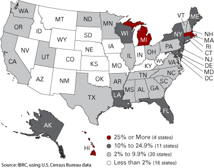
Land, according to the U.S. Bureau of the Census, accounts for 93.2 percent of the total area of the nation. Ten states, led by New Mexico, have less than 1 percent of their total area under water. If you look at Figure 1, you will find that four states have more than one-quarter of their total areas under water. Indiana ranked thirteenth among the fifty states in water as a percent of total area and is the “driest” of its neighboring states.
Figure 1
Percent of Land Area Covered by Water
As New York, San Francisco, Singapore, and other cities on water have shown, where the price for land justifies the cost, new land can be created. The fishing ground of your grandfather becomes the garbage dump for your mother, and is now the foundation for your home.
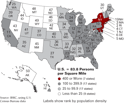
The U.S. density of population (based on land area) in 2005 was 83.8 p/sm. This was less than half the density in Indiana (174.9 p/sm), which ranked seventeenth most dense in the nation. New Jersey had the highest density at 1,175.3 p/sm (if we ignore the 8,966.1 p/sm for the District of Columbia). The lowest density was in Alaska at 1.2 p/sm. Michigan and North Carolina were closest to us at 178 p/sm while Georgia was the nearest trailing state at 157 p/sm (see Figure 2).
Figure 2
Density of Population Based on Land Area, 2005
What is the purpose and consequence of having a density figure? Presumably density correlates with something. Is it the case that low density offers us high costs? Or does high density mean lower costs from economies of scale and greater variety as consumers? Is it high or low density that gives us a sense of security? Is there more joy from living in New Jersey than from residing in Alaska?
The Concentration Index
Over time, the density of America’s population has been rising as the population has risen (the land area has remained constant except for areas flooded by dams). But density tells only part of the story. The distribution of our population among the states has become slightly more even over the years. One easy way to measure the differences in the distribution of population and land is see how much of the nation’s population would have to be shifted among the states to give each state the same population density. This measure is known by many names, but here we will call it the concentration index (CI) where
![]()
- %POPi = the population of state i as a percent of the U.S. population
- %AREAi = the land area of state i as a percent of the U.S. land area
- The sum of the absolute values of these differences, divided by two, equals the concentration index.
The higher the index, the more the population is concentrated. At an index of zero, the population would be evenly distributed all across a nation, state, county, or city. An index value of 100 would have all population concentrated within one subdivision of the larger entity. Along with issues of density we need to consider the distribution of population.
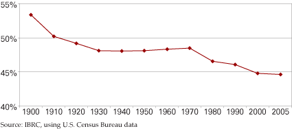
The concentration index quantifies the distribution of the population at a point in time. As seen in Figure 3, the concentration index is declining, which indicates that the U.S. population is becoming somewhat more evenly distributed among the states. In 1900, more than half (53.4 percent) of the nation’s population would have had to be redistributed to achieve equal densities. The index declined to 44.6 percent by 2005.
Figure 3
U.S. Concentration Index, 1900 to 2005
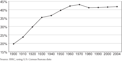
Contrary to the U.S. experience, the population in the state of Indiana is becoming more concentrated and less evenly distributed, with growing disparities in density. In 1900, the concentration index for Indiana was 19.6 percent. In 2004, the latest date for which we have data, that index stood at 41.8 percent (see Figure 4). Down from its peak in 1970, the CI for Indiana is rising again, indicating that an increase in the concentration of population is returning after a brief spurt of sprawl from 1970 to 1980. This finding is contrary to our common belief that population in the state is spreading out, sprawling over the countryside. Yet, as we will see, the process of redistribution is not universal among the state’s 92 counties.
Figure 4
Indiana Concentration Index, 1900 to 2004
Concentration and Sprawl within Indiana
Sprawl, that ugly word signifying the evils of modern life: congestion, isolation, and long commuting times. Or we could phrase it a voluntary redistribution of population to enjoy the benefits of single-family homes, open space, privacy, and independence from public transit systems. How has the population spread out or concentrated within Indiana counties? Is the population of our counties becoming more concentrated or more spread out (sprawled)?
There is no question that the population density of each county has been rising, but the distribution of population among the townships is vastly different. Let’s start with Cass County. In Figure 5, we see that the concentration of population among the townships of Cass County has been fairly unchanged over the decades. There was a peak at 56.5 percent in 1950 and a low at 46.7 percent in 1980, but the variations have been small. Contrast that with the line for Marion County. Here, the concentration index has been in steady decline from 1900 (when it measured 74.6 percent) to its low in 2000 at 16.4 percent. Where Center Township dominated the county in 1900, the population distribution of the county has recently become quite even.
Figure 5
Concentration of Population for Select Indiana Counties, 1900 to 2000
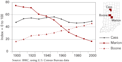
For a different contrast note Boone County in Figure 5. It started in 1900 as a typical farm county with a fairly even distribution and little concentration of 16.5 percent. By 2000, the population had concentrated to 45.5 percent just a little below steady old Cass County. Note that Marion County’s 2000 population distribution was almost identical with Boone County in 1900.
Figure 6 shows the year in which concentration in each county peaked. For those with peaks in 2000, we may think of Boone County with an agricultural past and a suburban present. For those with peaks early in the 20th century, we can think of Marion County where a central city has spread throughout its home county and is the force behind changes in neighboring counties.
Figure 6
Year Concentration Peaked in Indiana Counties

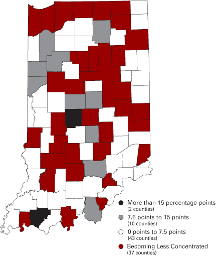
Between 1900 and 2000, the concentration index for 83 counties increased,
led by Warrick and Hendricks counties. Only nine counties had decreased
population concentration in that period with Marion and Floyd showing
the greatest declines.
But when we focus only on the second half of the century (1950 to 2000),
we find that 37 counties had declining concentration indices while the
remaining 55 counties were becoming more concentrated (see Figure
7).
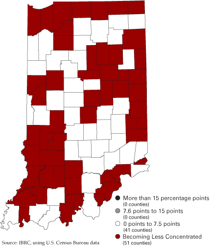
By the last decade of the 20th century, 51 counties had decreased concentration
measures.
Figure 7
Percentage Point Change in Concentration Indices in Indiana
1950 to 2000
1990 to 2000
Population concentrations and densities are not necessarily related and they do not have the same implications for businesses or governments. Too often we consider population densities alone and do not have a proper image of the population distribution within a geographic area. Consider, for example, a fire department serving 100,000 persons in an area of 10 square miles. If those persons are evenly distributed, the concentration index is zero. If, however, they are all within one jurisdiction because of park land and other protected areas, the nominal density remains the same, but the real density and service issues are quite different.
It might be best to adjust nominal density by the concentration index. Of course, we would want to use something more uniform than townships, but they will do until that superior unit arrives. With GPS capabilities and appropriately organized data, we could use both density and concentration to structure our thinking about population distribution more clearly than we do at present.
